
پرونده:Glacial lakes, Bhutan.jpg

پروندهٔ اصلی (۳٬۰۰۰ × ۱٬۶۶۵ پیکسل، اندازهٔ پرونده: ۱٫۹۸ مگابایت، نوع MIME پرونده: image/jpeg)
|

این تصویر بهعنوان نگارهٔ روز در ویکیانبار برای ۲۱ مارس ۲۰۰۷ انتخاب شد. زیرنویس آن به شرح زیر بود: سایر زبانها:
Қазақша: Хималайя арқаларындағы мұздықтар мен көлдер, Бутан |
خلاصه
| توضیح |
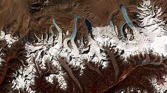
English: This image shows the termini of the glaciers in the Bhutan-Himalaya. Glacial lakes have been rapidly forming on the surface of the debris-covered glaciers in this region during the last few decades. USGS researchers have found a strong correlation between increasing temperatures and glacial retreat in this region. According to a joint press release issued by NASA and the U.S. Geological Survey, the great majority of the world’s glaciers appear to be declining at rates equal to or greater than long-established trends. This image from the ASTER (Advanced Spaceborne Thermal Emission and Reflection Radiometer) instrument aboard NASA’s Terra satellite shows the termini of the glaciers in the Bhutan-Himalaya. Glacial lakes have been rapidly forming on the surface of the debris-covered glaciers in this region during the last few decades. Français : Image de l'instrument ASTER (Advanced Spaceborne Thermal Emission and Reflection Radiometer) embarqué à bord du satellite Terra de la NASA montrant l'extrémité des glaciers hymalayens du Bhoutan.
Depuis quelques décennies, des lacs glaciaires se forment rapidement sur la surface couverte de débris de ces glaciers. Les scientifiques de l'USGS (United States Geological Survey) ont montré une forte corrélation entre la montée des températures et le retrait des glaciers dans la région. En Himalaya, les glaciers reculent a une vitesse alarmante et de plus en plus importante, ce qui est établi par la comparaison des données actuelles et historiques, ainsi que par la multiplication et la croissance rapide des lacs de surface de ces glaciers, selon Jeffrey Kargel, de l'USGS. |
|||||
| تاریخ | Data acquired on June 4, 2002, image released on June 8, 2006. | |||||
| منبع | http://visibleearth.nasa.gov/view_rec.php?id=2876 | |||||
| پدیدآور | NASA | |||||
| اجازهنامه (استفادهٔ مجدد از این پرونده) |
|

| مختصات دوربین | | محل قرارگیری این نگاره و سایر نگارهها در: نقشهٔ شهری باز |
|---|
تاریخچهٔ پرونده
روی تاریخ/زمانها کلیک کنید تا نسخهٔ مربوط به آن هنگام را ببینید.
| تاریخ/زمان | بندانگشتی | ابعاد | کاربر | توضیح | |
|---|---|---|---|---|---|
| کنونی | ۱۴ فوریهٔ ۲۰۰۶، ساعت ۰۰:۱۹ | | ۳٬۰۰۰ در ۱٬۶۶۵ (۱٫۹۸ مگابایت) | wikimediacommons>Brian0918 | larger version |
کاربرد پرونده
صفحهٔ زیر از این تصویر استفاده میکند: